There was a time when maps of the moon were created from telescopic observations and drawings. In fact, Sir Patrick Moore created maps of the moon that were used in the historic Apollo landings. Now, researchers have improved a technique that can create accurate maps from existing satellite images. Their approach uses a technique called “shape-from-shading” and involves analyzing shadows to estimate the features and shape of the terrain. Future lunar missions will be able to use the maps to identify hazards on the surface, making them much safer.
Researchers at Brown University in Rhode Island have refined a method for mapping the lunar surface, making it more accurate than ever before. Their paper, published in the Planetary Science Journal, by Benjamin Boatwright and his team details the improvements to the mapping technique. The method can create detailed models of the lunar surface to highlight craters, ridges and slopes from 2D composite images.
Close-up of the lunar surface (Source: NASA)
Highly detailed maps are crucial for lunar missions, helping planners find the safest landing site. They can also be used to identify areas of particular interest that require further investigation, making the entire mission much more efficient. Missions like the Artemis project will benefit as they head for the moon's south pole, an area that is not yet well mapped. High-resolution maps of the area will help autonomous landing systems avoid hazards.
Artistic depiction of the moon landing of Artemis
Creating the maps is a time-consuming task and it is difficult to get accurate results when the lighting in the target area is poor. Interpretation of shadows has not been very effective so far, but the team has addressed these issues. In their paper, the team explains how advanced computer algorithms can automate much of the process and improve the resolution of the models generated. Their new software gives lunar astronomers the necessary tools and information to create larger and more detailed maps of the surface.
For lunar researchers to create a map from images, at least two images of the same area are needed. Each image must be perfectly aligned with its counterpart, so that features in one image are in exactly the same place in the other image. Until now, this technology has not been able to take multiple images of an area and create a perfect map. Boatwright said: “We have implemented an image alignment algorithm that selects features in one image and tries to find the same features in the other image and then aligns them, so you don't have to manually track points of interest across multiple images, which takes many hours and brainpower.”
In addition to the image alignment algorithm, the researchers have developed quality control algorithms and filters to remove poor quality images from the alignment process. By only feeding good quality images into the process, the output is of far higher quality. It is a similar model used in astronomical imaging when multiple images are processed through stacking and alignment techniques.
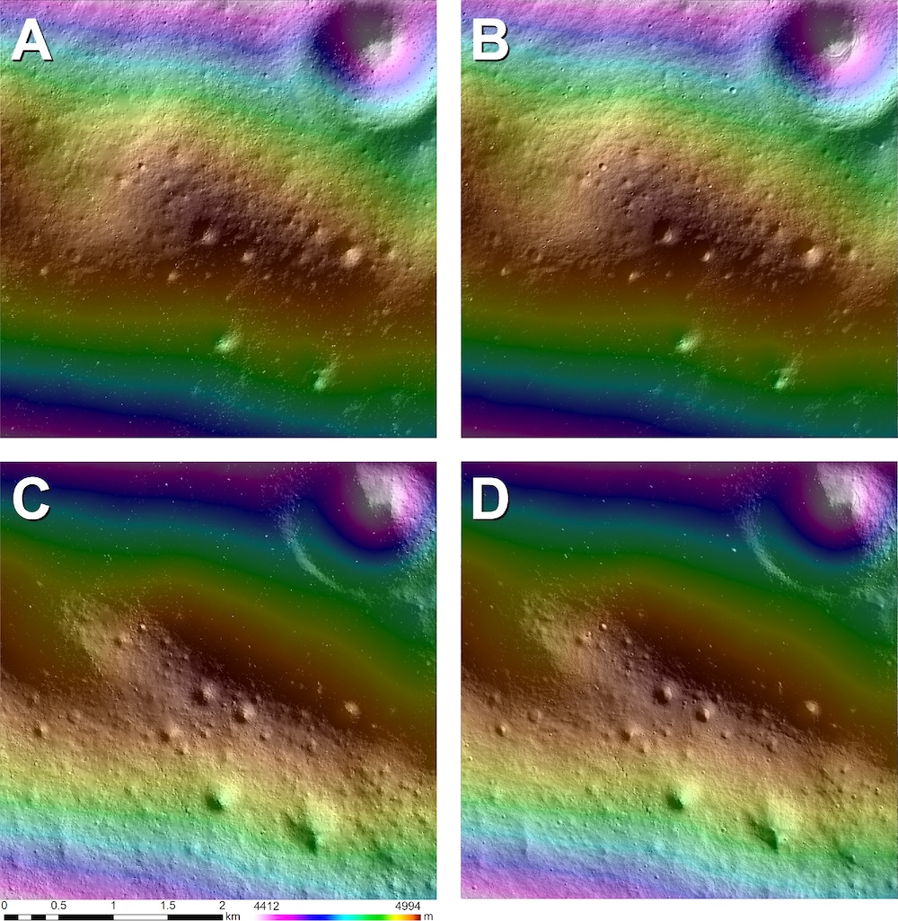
To evaluate the accuracy of their work, the team compared the results of existing lunar maps to find errors. They were pleased to find that the maps produced using their improved shape-from-shading technique were more accurate than those produced using traditional techniques.
Source: New technology from researchers at Brown University offers more precise maps of the lunar surface
Like this:
Is loading…