
Reposted by The Cliff Mass Weather Blog
January 06, 2021
North Pacific “hurricanes”
The North Pacific will never Experience a hurricane: a tropical storm with a sustained wind speed of 74 miles per hour or more.
They’re not called hurricanes, not because storms in the North Pacific aren’t as strong or stronger than many hurricanes. but because they don’t have a tropical character.
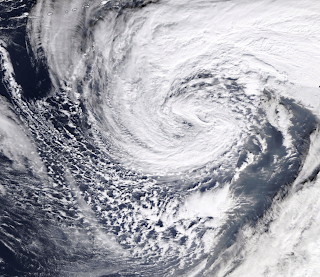
Clouds swirl in a very deep center of low pressure south of Alaska.
A number of extraordinarily intense storms have formed in the North Pacific in the past few weeks, some of which are putting most tropical hurricanes to shame. And later this week, a large Pacific storm will develop west of our coast, creating large waves and waves.
Consider the NOAA Ocean Prediction Center sea level pressure analysis for 10 a.m. PDT on December 31, 2020. A low center near the southwestern part of the Aleutian Islands had a central pressure of 921 hPa (mb), which is incredible. THE DEEPEST LOW PRESSURE RECORDED IN THE BERING SEA. It was the strongest storm that has ever hit Alaska.
How does the low pressure of this storm compare to hurricanes? Consider Saffir-Simpson’s hurricane categories often described by the media. The Pacific storm near the Aleutian Islands that day had a central pressure on the border between a Category 4 and Category 5 hurricane, and the associated winds far exceeded the requirements of a hurricane. Another low center (cyclone) to the east (west of our coast!) Had a central pressure of only 972, similar to a Category 2 hurricane.
And consider the following: Hurricane Andrew, which wreaked catastrophic damage in southeast Florida in 1992, had a central pressure of 922 hPa (mb) and was a Category 5 storm, and Hurricane Charley, Category 5 landed in Punta Gorda, Florida in 2004 with a central pressure of 941 hPa. Hurricane Katrina with 920 hPa caused widespread devastation in many densely populated areas of the central Gulf coast and had the third lowest central pressure ever measured in this area.
And one more thing: North Pacific storms are much bigger than tropical hurricanes. As a demonstration, here are images of the North Pacific storm on December 31 and Hurricane Laura (cat. 4) with the same horizontal scales. Two to three times as big.
Hurricanes get their energy primarily from the heat of the evaporated water, which is released as latent heat in the storm when large amounts of water condense. Hurricanes therefore need warm water (over 80 ° F) to survive. Storms in the North Pacific protect their energy from temperature differences between the Arctic and the subropics.
Another strong Pacific “hurricane” is expected to form on Friday / Saturday a thousand miles west of us with a low center of 960 hPa. Just a little weaker than the great Columbus Day Storm of 1962.
The sustained winds at that time (see below) showed a large area over 55 knots (63 miles per hour) and certainly the strongest winds will exceed the strength of the hurricane
And don’t worry about it hitting Washington State: it will swing north into the Gulf of Alaska and eventually weaken. But the storm will create HUGE waves that can reach 40-50 feet (significant wave height, see forecast for Saturday), and some of them will hit our coast on Sunday (see forecast graph), even though they are significantly attenuated (maybe 30 feet).
4.8
6th
be right
Item rating
Like this:
Loading…
Comments are closed.