
From the Cliff Mass Weather Blog
Cliff Mass
My group and scientists from the University at Albany are currently studying the meteorology of the LA wildfires earlier this month and have important initial results. At last week's meeting of the American Meteorological Society, I attended many sessions on wildfire meteorology and spoke with several colleagues who have actively studied such events. The fires in LA caused heated discussions.
We have a good idea of what happened: an extreme/unusual event in Santa Ana associated with strong slope winds. In this blog I will show you some early simulations and explain why this event occurred.
I will also describe why Climate change did not play a significant role.
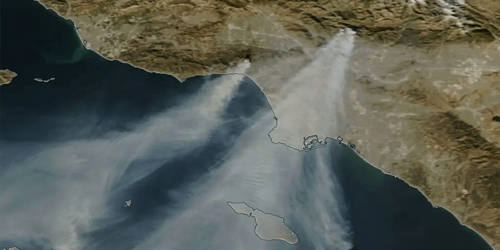
As I explain below, this is not just a Santa Ana event, but an unusual one, with extreme winds blowing to lower elevations. Some lower-elevation stations, such as Burbank, experienced the strongest wind gusts on record. Model simulations suggest the development of what is known as a High amplitude mountain wave leading to a descending storm event.
Santa Ana 101
Santa Ana is associated with strong northeasterly (north to east) winds over Southern California. These strong winds are accompanied by very low relative humidity and are very favorable for wildfires in southern California.
The typical large-scale weather pattern associated with Santa Anas includes a large area of high pressure over the Great Basin, with the strongest events also having a low center to the southwest (see below). Such a pattern results in strong northeasterly winds approaching the mountains of southern California.
The observed sea level pressure pattern at 4 p.m. on January 7 (below) showed many of these elements, with the low to the south particularly strong (Warm colors indicate above normal pressure, cool colors indicate below normal pressure).
This pattern led to extreme, perhaps unprecedented, developments. Northeast winds approach the region in the lower atmosphere. For illustrative purposes, the color shading in the map below shows wind differences from normal at 925 hPa (approximately 2,500 feet above sea level) at 10 p.m. Tuesday evening (January 7). The light gray indicates very unusual winds (more than six standard deviations from normal). In some places the wind direction and speed are also displayed.
TIt wasn't a normal Santa Ana.
High-resolution simulations
To understand what happened, UW Research Scientist David Ovens, a member of my research group, created a very high resolution prediction/simulation of the event using the WRF model with a grid spacing of 1.3 km (that's very high resolution). carried out.
Let me show you a surface wind gust forecast (32 hours after the forecast began) for 12:00 a.m. on Wednesday, January 8th. The areas of the Palisade and Eaton fires (the two largest) are outlined in red.
Extreme winds (with gusts in excess of 70 knots, 81 miles per hour) were forecast over and downwind of the San Gabriel Mountains. HUGE threat. Weaker but still strong winds (gusts of 50-60 mph) will be experienced in the Palisades area extending west and south.
To understand what is going on, it is helpful to draw vertical cross sections through the fire areas to show the three-dimensional atmospheric structure. Below is a cross-section (as of 8 p.m. Tuesday) of the Eaton fire; a section that traverses the San Gabriel Mountains. The shading shows sustained winds in knots, the x-axis is horizontal distance, and the y-axis is pressure altitude (700 is about 10,000 feet).
Wow. Very strong acceleration of air as it descended on the southern slopes of the San Gabriels, with the strongest winds near Altadena where the fire was raging crazy. It was a very strong slope wind storm with a greatly enhanced mountain wave pattern.
Another cross-section, this time through the Palisades fire at 10 a.m. Wednesday. January 8th is shown below. Very strong winds leeward (south) of both the interior mountains and the Santa Monica Mountains to the south (left side of figure).
This and previous simulations from the UW-WRF model and NOAA/NWS models (such as HRRR, High Resolution Rapid Refresh) predict the extreme slope winds DAYS in advance
It was also clear that unusually large quantities of dried “fuel” were ready to be burned. Fuel loads were particularly high after TWO unusually wet winters (2022-2023, 2023-2024). A dry start to winter meant that huge amounts of fuel were available for combustion.
This was clearly a situation with an exceptional, extreme risk of forest fire. That's why I blogged a dire warning the day before. Why the National Weather Service did the same thing. The officers in LA should have known there was a serious threat.
All that was needed was an ignition source. In the deadly and large Eaton Fire near Pasadena, a problematic power transmission tower appears to have been the origin of the fire.
The Palisades Inferno was either the smoldering embers of a New Year's Eve fireworks display or the failure of some aging power lines found north of Skull Rock. Perhaps arson is another possibility. Several fire experts I spoke with at the AMS wildfire meeting believed the power lines were the most likely cause, but a final assessment is not yet available.
What Is It is clear that LA did not shut off the region's power even AFTER the fire began and that there were limited firefighting resources before the fires began. Not good.
Conclusion: A very cleverly predicted Santa Ana event with record-breaking winds hit LA earlier this month. Two wet winters resulted in unusually high levels of dried fuel. Human ignitions started the fires.
Impact of global warming
There are several media outlets and climate activists who suggest that the LA fires were the result of global warming or were significantly exacerbated by human-caused warming.
These claims contradict the best science, This suggests minimal impact from human-caused warming.
Such claims undermine the significance of key societal failures, from failing to shut off electricity and fireproof homes to inadequate firefighting capacity or adequate warning and evacuation protocols.
Main reasons for global warming not an important factor contain:
1. There is no evidence that global warming is increasing Santa Ana winds. In fact, there are strong physical reasons (with supporting scientific literature) that global warming is WEAKING the Santa Ana winds.
2. Available fuels were unusually plentiful as the previous two years were much wetter than normal. There is no evidence that this is due to global warming. And there is no long-term trend toward wetter winters that would be obvious if this were a climate issue.
3. The immediately preceding months were drier than normal. This is not predicted by global warming forecasts and there is no historical trend toward drier early winters that would occur if climate were a cause (see graph below of Los Angeles precipitation from October 1 to January 6).
3. There are some outrageous claims that the LA fires are the result of increasing “Weather whiplash” due to climate change. This “whiplash” theory is not supported by observations such as the illustration shown above.
I am particularly concerned about the media spreading untrue weather/climate theories. A prime example is the unconfirmed claim that the Lahaina fire was related to the southward passage of a hurricane. This turned out to be wrong.
Like this:
Load…
Related
Explore more from Watts Up With That?
Subscribe to receive the latest posts by email.
Comments are closed.